Cycle with a view
Pack a lunch and head out on this seasonally opened road to feast along the shore of one of the largest bodies of water in the Adirondack Park, which is completely surrounded by a forest preserve.
How to get there
Start at the well-signed parking area for Gulf Brook Road, located along Essex County Route 84 (aka Blue Ridge Road), 7.2 miles west of Exit 29 of the Adirondack Northway (Interstate 87).
Parking for those intending to do the Intermediate or Difficult ride is at the parking area that is a few hundred feet off the Blue Ridge Road (Essex County Route 84) (Coordinates: 43.955676, -73.872265).
The Easy ride starts from the Fly Pond Parking Area further along the gravel road and beyond the moderate to steep 2-mile climb described below. This option is only possible from late-spring through fall, when the gates along the road are opened to allow motor vehicle access. If you are intending to do the Easy ride it is best to contact the NYS Department of Environmental Conservation at (518) 897-1200 to confirm that the gates to the Fly Pond Parking Area are open before heading out. The coordinates for the Fly Pond Parking Lot are 43.981132, -73.900719.
By the numbers
- Level of difficulty: Easy (seasonally, when the entrance gate is open and motor vehicle access to the recommended starting point is possible), Intermediate, or Difficult
- Route length: Easy 6.9 miles (11 kilometers), Intermediate 13.2 miles (21.2 kilometers), Difficult 19.6 miles (31.5 kilometers)
- Elevation gain / loss: Easy: 525 feet (160 meters), Intermediate: 1,255 feet (382 meters), Difficult: 1,769 feet (539 meters)
- Loose dirt and gravel
The easy route
Riding the Gulf Brook Road will take you deep into an Adirondack hardwood forest where you may very well see signs of moose, bear, and coyote. It offers you solitude and the potential for a deeply personal and unique experience. This ride is why you ride unpaved roads, and it is a ride like this that will rev you up and get you to hop on your bike for the next adventure. Those planning to ride the Easy route should not be discouraged by this description as they are driving this section to the Fly Pond Parking Area and should read on as there are opportunities to do a ride over rolling terrain that begins beyond this more challenging stretch of road.
Intermediate and difficult routes
For those riding the Intermediate or Difficult routes, heading out from the parking area means a quick gain of nearly 500 feet of elevation in a little less than 2 miles. For much of this time the grade is moderate, however a few short stretches of this dirt road have challenging grades of 10%.The grade will grab your attention on the way up, and the way down, where speed control over this loose surface is important.
The trails
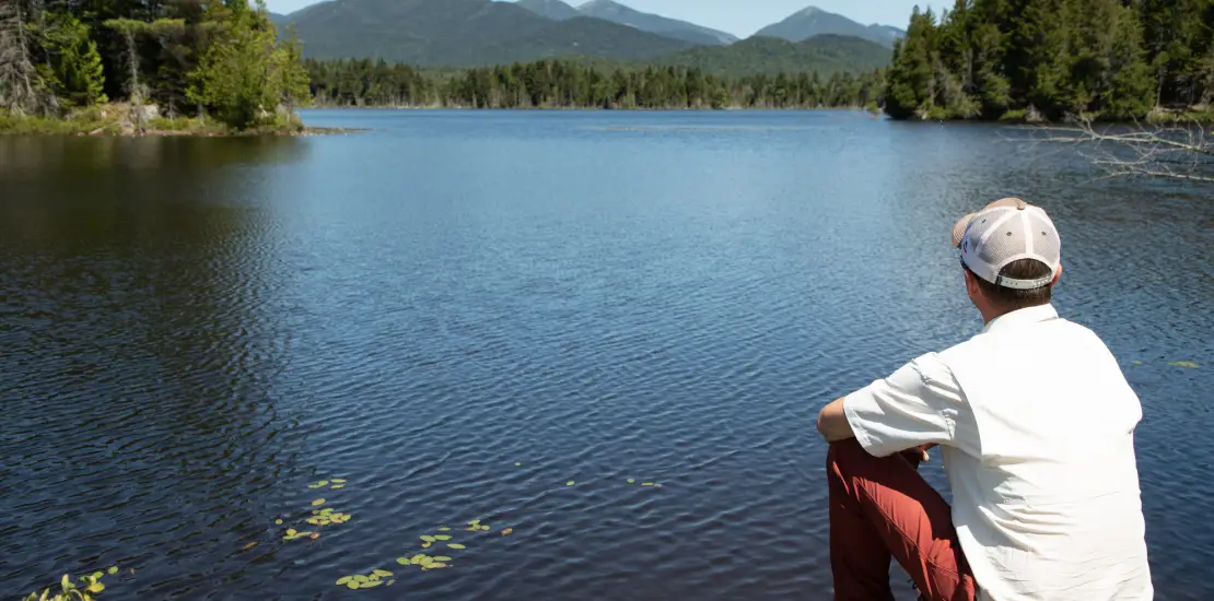
From the height of land which occurs at the 2-mile mark the road becomes a super fun romp over rolling terrain. You roll by the Fly Pond Parking Area at mile 3.2; this is where those planning to do the Easy ride would park and begin their fun. The easy rolling terrain continues until the 5.2-mile mark; this is the 2-mile mark for the Easy ride. The road then makes a sweet noticeably steeper half-mile descent to the bridge over LaBier Flow, and to the ride’s first spectacular view. This is a great location to take a break and soak in the sun and great scenery. Once your soul is satiated, settle back onto your saddle and climb to the top of a small rise to the Four-Corners Parking Area, turn right passing by an old hunting cabin and continue into a northern balsam fir forest for a little less than a mile and half to the turnaround point of the ride. However, the terminus isn’t the end of the fun. The parking lot beyond which bikes are prohibited is just 500 feet from the pond itself. Leave your bike behind, grab your windbreaker and snacks, and follow the road to the dam where a most perfect view of Boreas Pond and the High Peaks region awaits.
For those intending to only ride the Easy or Intermediate rides this is the point where you retrace your steps to return to your car. However, if you’re interested in up to 6.4 miles of much more difficult riding, you can retrace your route to the Four-Corners Parking Area then continue straight (instead of taking the left back over the LaBier Flow dam) to a barrier that marks the start of private land. This more difficult 3.2-mile spur is a poorly maintained road and will eat up time and energy but is a lot of fun if you’re up for a challenge. It is also not included in the RideWithGPS route. You should expect to have to carry your bike over downed branches or trees, or over washed-out culverts, and it should only be considered by more advanced riders.
Additional information
The solitude of the Gulf Brook Road comes at the cost of extra preparation before heading out. This is especially true, should you choose to do the Intermediate or Difficult rides when the gates are closed as even fewer people will venture into this stretch of wilderness. There is no cell service in this area, and if you do find yourself hurt you can call 911 or the NYS Forest Rangers (1-833-697-7264), but to do so you or someone in your party must get out to make the call. If you have a mechanical problem, you may have to push your bike back to your car. As such, everyone in your riding party should bring proper clothing for the weather, food, water, and a spare tube that fits their bike. A first aid kit, and a handful of necessary tools (including a bike pump and tire levers) are also helpful. It is best to bring a bug net and bug spray if you plan to visit Boreas Ponds in the spring or early summer, as mosquitos and black flies can be quite bothersome.
Due to limited cellular coverage, please be sure to download this route and save for offline use before you leave home.

